UtilityVision AR
FIELD GEOSPATIAL · FTTH
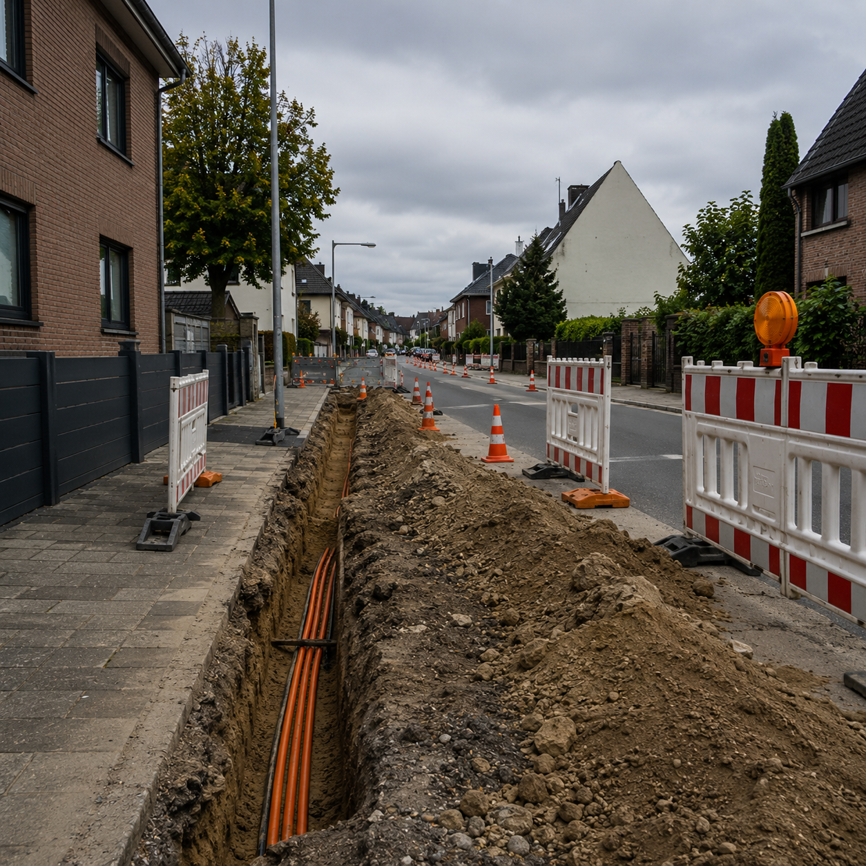
Scan the trench.
See what's buried.
See what's buried.
LiDAR as-built capture and AR Leitungsauskunft — compliant documentation and underground vision in one field tool.
RTK GNSS ±2 cm
ETRS89 / UTM32
DIN 18220
Concept & product: Cristian Oprea · Engineering partner — for GIG Infrastructure GmbH
SELECT PROJECT
GIG Infrastructure — NRW
CO
C. Oprea
{{ project.city }}
/
{{ project.area }}
RTK FIXED ±2 cm
SAT 24
Synced
82%
14:32
ACTIVE TRASSE
{{ project.city }} · {{ project.area }}
Documented
Open trench
Pending
Trench overview
{{ project.active }} open
{{ stats.awaiting }}
awaiting documentation
{{ stats.scans }}
scans this week
TRENCHES
RECENT SCANS
{{ s.name }}
{{ s.meta }}
0.45 m
QUERSCHNITT · CROSS-SECTION
HDPE Rohrverband
LWL Ø40
Graben edge
{{ g.label }}
{{ g.conf }}
TIEFE / DEPTH
{{ depthStr }} m
BREITE / WIDTH
{{ widthStr }} m
{{ progressPct }}
SCANNED
RTK FIXED
Quality {{ scanQuality }}
As-built · GR-114±5 cm GNSS
Süchtelner Straße · {{ project.city }} · ETRS89/UTM32 · 14:31 · DIN 18220
3D AS-BUILT · POINT CLOUDdrag to rotate
● Gas duct● Fiber Rohrverband● Water
QUERSCHNITT · CROSS-SECTION
Detected objects6 / 6 classified
{{ d.name }}
{{ d.meta }}
Data source: GIS / KMZ — overlay accuracy varies. Always probe before excavation.
UTILITY LAYERS
X-RAY DEPTH
{{ depthCutStr }} m
0 m2.5 m
Reveals utilities down to the set excavation depth.
{{ selectedLine.type }}
{{ selectedLine.owner }}
DEPTH
{{ selectedLine.depth }}
MATERIAL
{{ selectedLine.material }}
UPDATED
{{ selectedLine.updated }}
CONFIDENCE
{{ selectedLine.confidence }}
{{ selectedLine.note }}
Conformity reports
{{ project.city }} · {{ project.area }}
Generating conformity report…
Compiling as-built · GNSS · photos · DIN 18220
Report generated and ready to export.
{{ activeReport.id }} · As-built conformity
{{ activeReport.meta }}
±5 cmDeepUp / GIS compatible
DIMENSIONS
Tiefe / Depth0.85 m
Breite / Width0.45 m
Sandbettung0.15 m
Länge / Length42.6 m
Koordinaten51.255N 6.394E
METADATA
Bauleiter: C. Oprea
Datum: 30.06.2026 · 14:31
CRS: ETRS89 / UTM32N
Norm: DIN 18220 · konform
Datum: 30.06.2026 · 14:31
CRS: ETRS89 / UTM32N
Norm: DIN 18220 · konform
PHOTO & SECTION
EXPORT
Settings
Device, corrections and data sources
RTK RECEIVER
Emlid Reach RX
SN 23-A4F09 · Firmware 31.5
NTRIP / CORRECTION
SAPOS NRWStreaming
MountpointVRS_3_4G_NW
SolutionFIX · 24 sats
Latenz0.8 s
DATA SOURCES
{{ ds.name }}
{{ ds.meta }}
ACCOUNT
CO
Cristian Oprea
Bauleiter · GIG Infrastructure GmbH
128
scans
96
reports
6
Trassen